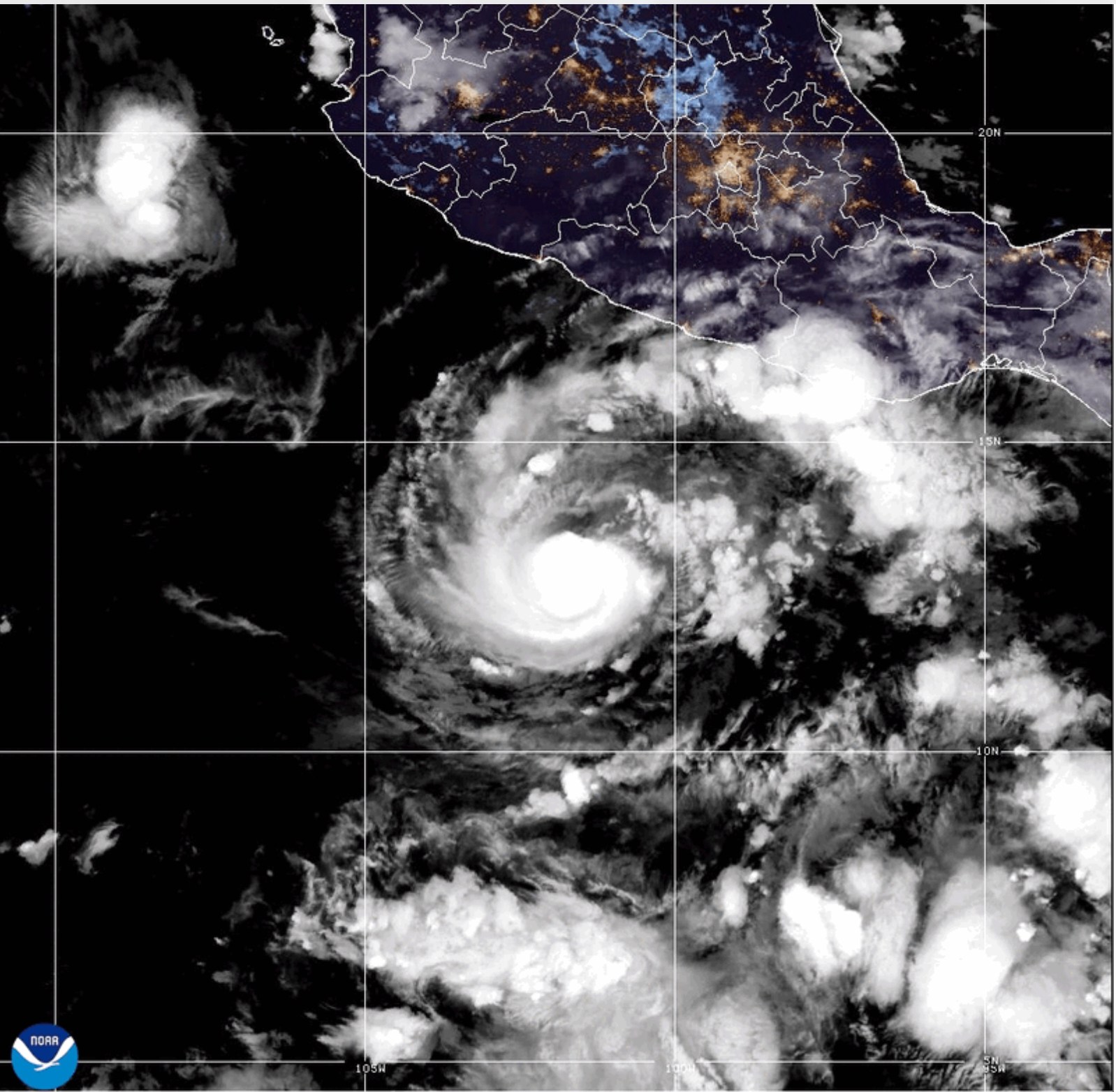
Hurricane Trudy lashes Mexico’s Pacific coast with heavy rain and winds
The U.S. National Hurricane Center warned of life‑threatening flooding and mudslides as Trudy moved northwest along Mexico’s southwestern shoreline.
By Felo News Desk · Published
Hurricane Trudy struck Mexico’s Pacific coast on Sunday, delivering heavy rain and strong winds, while the U.S. National Hurricane Center warned of potentially life‑threatening flooding and mudslides, according to multiple news outlets.
What happened
The storm, classified as a Category 2 hurricane, maintained maximum sustained winds reported between 100 mph (155 kph) and 105 mph (165 kph). At the time of reporting it was located roughly 135 miles (215 km) south‑southwest of Cabo Corrientes in Jalisco state and about 115 miles (185 km) west‑southwest of Manzanillo, moving northwest at 9‑10 mph (15‑17 kph). A hurricane warning extended from Manzanillo, Colima to Cabo Corrientes, Jalisco, while a tropical storm warning remained in force for the Islas Marías. Warnings for the coast east of Punta San Telmo to Lázaro Cárdenas had been lifted.
What the reports add
- CityNews in Toronto and the Winnipeg Free Press reproduced the Associated Press bulletin, echoing the wind speeds and warning zones.
- The Independent published two separate stories: the earlier piece listed sustained winds of 100 mph (155 kph) and a forward speed of 9 mph (15 kph); the later version raised the wind estimate to 105 mph (165 kph) while keeping the same location and movement data.
- All four outlets noted that Typhoon Champi was intensifying into a Category 4 super‑typhoon as it passed Guam.
- Both Independent articles added that Trudy could see slight strengthening on Sunday morning before weakening later in the day.
- Source 4 included a Reuters photo caption describing a man on the shoreline in Boca de Apiza, Michoacán as the hurricane advanced.
- Colima authorities were quoted as saying the overall risk remained low, but warned that already‑saturated ground could lead to damage from heavy rainfall.
What was said
The Mexican navy urged mariners and coastal residents to exercise extreme caution because of high waves, heavy rain and the risk of rising rivers, flooding and landslides, as reported by all four sources.
How it came about
Earlier coverage by Felo News on October 16 reported Trudy strengthening to Category 3 while positioned about 420 km southwest of Acapulco, with sustained winds of 120 mph (195 kph) and a slow northwest drift. A October 17 update described the system as a Category 1 storm with 90 mph (150 kph) winds, located 240 miles west‑southwest of Acapulco and 215 miles south‑southeast of Manzanillo, moving northwest at 8 mph. Those pieces provide context for the storm’s rapid intensification and the expanding warning area now in effect."
Key facts
- Hurricane Trudy was a Category 2 storm with sustained winds of 100‑105 mph (155‑165 kph). (toronto.citynews.ca)
- The storm was located about 135 miles (215 km) south‑southwest of Cabo Corrientes, Jalisco. (independent.co.uk)
- A hurricane warning covered the coast from Manzanillo, Colima to Cabo Corrientes, Jalisco. (winnipegfreepress.com)
- The Mexican navy warned of high waves, flooding and landslides. (independent.co.uk)
Where accounts differ
- Maximum sustained wind speed reported: 105 mph (165 kph) (toronto.citynews.ca); 100 mph (155 kph) (independent.co.uk)
- Forward speed of the storm: 10 mph (17 kph) (toronto.citynews.ca); 9 mph (15 kph) (independent.co.uk)
Timeline
- 2026-10-16 — Felo News reported Trudy intensifying to Category 3 near Mexico’s Pacific shoreline.
- 2026-10-17 — Felo News noted Trudy as a Category 1 storm approaching the coast with a warning from Manzanillo to Cabo Corrientes.
- 2026-10-18 — Hurricane Trudy makes landfall with heavy rain and strong winds.